


Book Tickets Online
About
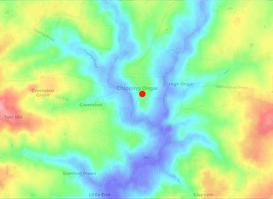
Chipping Ongar (to give the town centre its proper title) is derived from two Old English words meaning ‘market’ and ‘grazing land’. It was the centre of the Saxon administration of the Ongar Hundred and was probably a Saxon ‘burh’ (a fortified settlement). It is situated in a key position on the land between the coming together of two key waterways, the River Roding and Cripsey Brook. This brought together access to water, transport and protection plus fertile plains along the water's edge for grazing and growing winter fodder. The valleys carved out over time by these waterways also gave Ongar prominence over the surrounding countryside with uninterrupted views to the south in the direction of London and towards the nearest surrounding high points at Epping Forest in the west, North Heath in the east and Little Laver in the north. This combination made Ongar an important centre in Saxon times and the ideal place for a mound topped with a castle when the Normans arrived, although the strategic importance for Norman Ongar was probably more a continuation of its administrative importance for the surrounding area.
Ongar – the Norman town and influence of the Counts of Boulogne
Medieval Ongar can be visually traced within its current layout, centred on the castle and grounds, the high street and the mid-12th century church. Documents and current place names can take us back even further to the Saxon town. For example, an Anglo-Saxon will of 1015 mentions Ongar Great Park, making it the oldest recorded park in England.
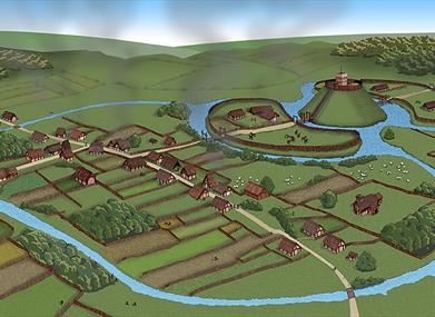
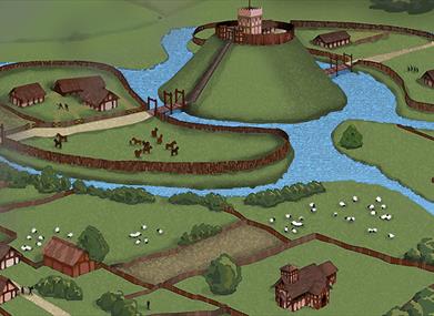
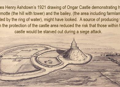
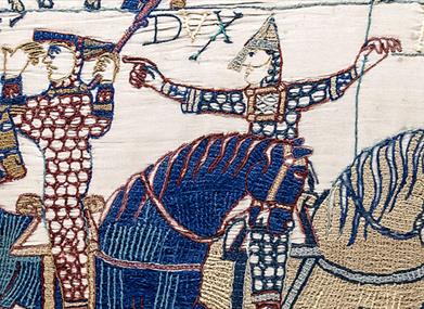
Everything changed in 1066 with the conquest of England by Duke William of Normandy. Crowned King Christmas 1066, William subdued the country by ceasing former lands of the Saxon nobility and granting them to knights who had fought alongside him during the invasion. These new overlords controlled the country by building strongholds on their new lands, fortified houses or wooden castles at first to be replaced by more elaborate stone castles. These were Motte and Bailey Castles, the motte being a man-made hill with castle on top, surrounded by fortified grounds, the bailey, and often surrounded by a moat. Ongar typifies the layout with the motte and bailey still visible, but the castle long gone.
At the time of the conquest, Ongar was ‘held’ by Thelgyth, the widow of Thurstan according to the Doomsday Book. From Thelgyth it passed to Ingelric the Priest who gifted it to the house of St Martin-le-Grand in London in 1068, two years into Norman rule.
Evidence is scant concerning the Lordship of Ongar until the creation of the Doomesday Book in 1086 where Ongar is shown as a possession of Eustace, the Count of Boulogne. Depending on the point in the eighteen years between the two evidential documents, at which Ongar passed to the Counts of Boulogne, this could either have been Count Eustace II, who fought alongside Duke William at Hastings, or his son Eustace III whose daughter became the wife of King Stephen of England and whose brother was crowned King of Jerusalem. Two dates have been put forward for the death of Eustace II, 1080 and 1093, which fall either side of the Doomsday book adding further confusion to the identity of which Count first held Ongar. Whichever it was, the Doomesday records show him to be the tenth largest landowner in England. Adding his Essex and Hertfordshire lands, plus lands owned in the north of England, to the extensive lands owned in northern Europe, the Lord of Ongar was no ordinary noble and the fiefdom of Ongar was part of an extensive realm stretching across the country and overseas. The fact that the Counts of Boulogne featured in the Doomesday Book at all is intriguing as Eustace II was banished by King William in 1067, with his lands forfeit, after Eustace’s failed attempt to seize England whilst the king was absent in Normandy. The fact that William and Eustace were reconciled a few years later, and the Count regained all his estates, can be put down to the politics and necessary alliances of the time. More on this, and the links of the Counts of Boulogne to the major events of the time, below.
Upon the death of Count Eustace III, around 1125, all his estate (known as the Honour of Boulogne), including his Essex fiefdom, centred on Ongar, passed to his daughter Matilda who married Stephen of Blois, nephew of King Henry I of England (who had arranged the marriage).
Around the death of Stephen, now King of England, in October 1154, his son William IV Count of Boulogne, passed the manor of Ongar to Richard de Lucy, a loyal supporter of Stephen’s, and probably William’s son-in-law through marriage to his daughter Rohese. Under his new king, Henry II, Richard became Sherriff of Essex and Hertfordshire and then Lord Justice of England. Henry fully invested the manor of Ongar in Richard and added additional land at Greenstead and Stanford. Whilst fighting for Henry II abroad and running England in the king’s absence, Richard fortified the town and enlarged the castle and bailey to an extent that it was described upon completion in 1162 as a ‘great’ castle alluding to its size and importance. It is this final rendition of the medieval fortified Ongar, home to one of the most important men in England, that we see the footprint of today. At the end of his life, Richard resigned his office and retired to Lesnes Abbey, which he had founded in Kent (now in ruins and within the London Borough of Bexley), where he died three months later on 14 July 1179. He died a very wealthy man with land and retainers in England and France.
According to the de Lucy family archives, upon the death of Richard de Lucy, Ongar passed to his third son Godfrey, Bishop of Winchester until 1194 when it was handed to Geoffrey de Lascelles, the husband of Maud, the daughter of Richard de Lucy's granddaughter, also named Maud. However, they also record that in 1180, Ongar and Stanford were granted to Richard’s youngest son Hubert who died without issue.
The castle was eventually demolished in the 16th Century and the mansion built on the site suffered a similar fate in 1744.
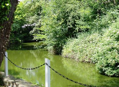
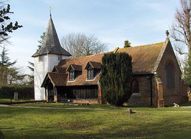
Today the castle and its grounds are privately owned. The motte, over 50 feet high, still remains, albeit covered by trees and undergrowth, as does the surrounding moat and the inner bailey and remnants of the outer moat and a surrounding wall. A public footpath around part of the site allows a glimpse of the mound – better in the winter when the trees are bare. Traces of the town’s medieval layout can be discerned, linking the castle grounds to St Martin’s Church and down to Cripsey Brook which would have provided water to the castle’s moats. Travellers along modern Ongar High Street pass through two pinch-points where the road narrows between buildings and these define the extent of the medieval town and the points which would have been gateways through the fortifications. To the east of the town is the important River Roding and to the west, St. Andrew's, an 11th century Parish Church at Greensted and the oldest wooden church in the world.
Find out more about the Counts of Boulogne and their exploits whilst at Ongar here.
People who enjoyed this page also enjoyed discovering the true story and hangman confession of Dick Turpin and finding out about a remarkable and unique fort, the North Weald Redoubt
Map & Directions
Road Directions
Car-parks in Ongar:
•The Pleasance Car parks (x3) are located at CM5 9AB next to the Library, Sainsbury’s supermarket and The Budworth Hall
•Ongar South Car park is located at CM5 9HD opposite The Two Brewers Pub.
Directions from Central London:
Navigate to the M11 heading north, come off at Junction 5, then take the A113 signposted to Stapleford and Ongar. At the junction with the A128, continue north on the A128 signposted to Ongar and Harlow. The A128 runs right through the middle of Ongar and goes past all the main car parks, the South car park is on your left just before you go over the river bridge, opposite The Two Brewers Pub.
Directions from East London:
Navigate to the A12, heading east. Continue to follow the A12 and at Junction 11, take the turning for Brentwood. Travel into Brentwood town centre, follow signs for the A128 signposted to Ongar, and follow this road through Pilgrims Hatch and Kelvedon and onto Ongar. The A128 runs right through the middle of Ongar and past all the main car parks.
Directions from the East:
Navigate towards Chelmsford and take the A414 signposted to Harlow. Once leaving Chelmsford, go straight over two roundabouts, continuing to follow the A414. At the Four Wantz Roundabout, take the left hand turning onto the A128, signposted to Ongar. As you approach the High Street you will pass The Pleasance car parks on your right and left, one next to the Library and the other opposite The Budworth Hall. A further car park is situated next to Sainsburys supermarket, just past The Budworth Hall.
Directions from the West:
Navigate towards Harlow (if coming along the M25, take Junction 27 onto the M11 heading north, signposted to Harlow and Cambridge, then come off the M11 at Junction 7). Take the A414 heading east, signposted towards Chelmsford. Go straight over two roundabouts. At the Four Wantz Roundabout, take the right hand turning onto the A128, signposted to Ongar. As you approach the high street you will pass The Pleasance car parks on your left and right, one next to the Library and the other opposite The Budworth Hall. A further car park is situated next to Sainsbury's supermarket, just past The Budworth Hall.
Public Transport Directions
By Bus:
Visiting Ongar by bus saves the hassle of driving and parking and is environmentally friendly. There are regular bus services from a number of major centres:
Further details, timetables, fares and journey planners can be found here: http://www.traveline.info/
By Train:
Take the train to London, then head for the London Underground Central Line, travelling East-bound. Take care to ensure your train is going to Epping (and not “Woodford via Hainault”). Epping is in Zone 6. Epping station offers step free facilities for the disabled.
Full timetables, fares and journey planner are available on www.tfl.gov.uk/tube
From Epping you can take a 339 heritage bus as part of the heritage railway services, these seamlessly integrate with the steam or diesel hauled heritage trains serving Ongar.