


Book Tickets Online
About
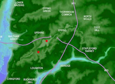
Ambresbury Banks is one of two Iron Age Forts to be found within Epping Forest and is close to Epping Town. The other, Loughton Camp, as its name suggests, is close to Loughton. Both were roughly the same size covering an area of around 10-11 acres or approximately six football pitches. Both are on a ridge of high ground that rises from the direction of London which reaches its highest point in Epping (where the high street is the same height above sea level as the cross on the top of St Pauls Cathedral). At Loughton Camp in particular, the land falls away quite sharply on its southwestern edge. Unlike today, where the forts are hidden within the ancient forest, during the Iron Age the surrounding land would have been cleared of trees for agriculture and visibility, giving them the advantage of being on the highest point for both defence and as lookout posts. Today, whilst Loughton Camp is still buried quite deep within the forest, Ambresbury Banks can be glimpsed through the trees whilst travelling along the Epping Road near its junction with Crown Hill. Both sites are scheduled monuments and should be visited on foot only.
The fort at Ambresbury Banks
Experts believe that the fort was constructed around 700 BC and last occupied around 42 AD. The second occupation occurring just before the Roman occupation of England, is evidenced by work carried out recutting the ditches, presumably at a time when the fort was repaired and put back into use.
Although termed Iron Age Hill Forts, there is no evidence that Amresbury Banks was built solely for military purposes. These enclosures on high ground were equally likely to be used as a place of gathering or safety for the local people and somewhere to keep harvest and livestock secure. They may also have been used as a lookout and to establish boundaries between tribes. Finds within the fort have included shards of red, grey and black pottery, flints and flint arrow heads, and lumps of baked clay.
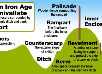
The fort encircles an area of 11 acres (4.5 hectares) and is surrounded by a single bank of 6 ft (2 m) in height, together with a ditch (these measurements may have been as much as 3 m originally). There is a small counterscarp bank on the outside lip of the ditch. A stream flows through the site which may have been dammed at times to provide a water source. Although the fort was built with a single entrance, approached from the north west, over more recent times the surrounding bank has been breeched in five other places as tracks have cut across the land, one following a parish boundary.
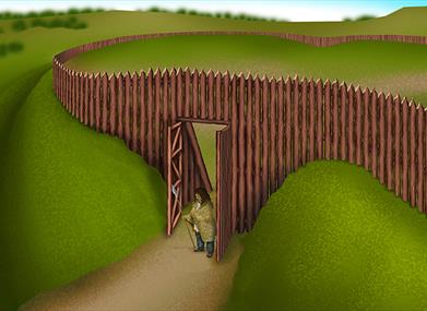
Iron Age forts like Ambresbury would have been constructed by digging the defensive ditch and piling the spoil around the inner edge to form the bank on top of which a wooden fence or palisade, could be constructed. This would have created a formidable defensive structure with anyone looking to enter uninvited standing in the ditch looking up at a bank and fence many times their height, with defenders looking down on them, possible from platforms or banks within the fort raising them above the top of the fence. However, unlike more elaborate Iron Age forts (some of which could have two or three surrounding concentric defensive banks and ditches), there appears to have been no attempt to revet the banks at Ambresbury. That is, to solidify the earth banks by facing them with stone to better hold them in place and protect them from slide and erosion, especially where they might have to bear the weight of a strong fence placed on top. The only revetment on the site was found on the bank edges at the original entrance, suggesting the use of gate posts. This suggests a basic construction more in keeping with temporary or emergency defensive use and more likely to be a community asset for gathering and working, livestock, storage and as a lookout.
Legend of Boudica
According to legend, Ambresbury Banks was the battle site of the last stand by Boudica against the Romans in 61 AD. However this is one of a number of sites put forward including as close as Kings Cross in London and far away as Mancetter in Warwickshire. However it is possible that this fort, together with its neighbour Loughton Camp sit on the boundary between the warring tribes the Trinovantes and the Catuvellauni.